Escape the Crowds: 5 Lesser-Known Hikes in Eryri (Snowdonia)
Company’s great… most of the time. But if you're craving solitude, here are five of the best quiet hikes in Snowdonia.
Tired of packed parking and crowded summits? This guide reveals 5 of Snowdonia’s best hikes that offer all the beauty without the buzz. Whether you're after quiet forests, secret waterfalls, or wide-open views, these under-the-radar hikes are your ticket to solitude in the wild.
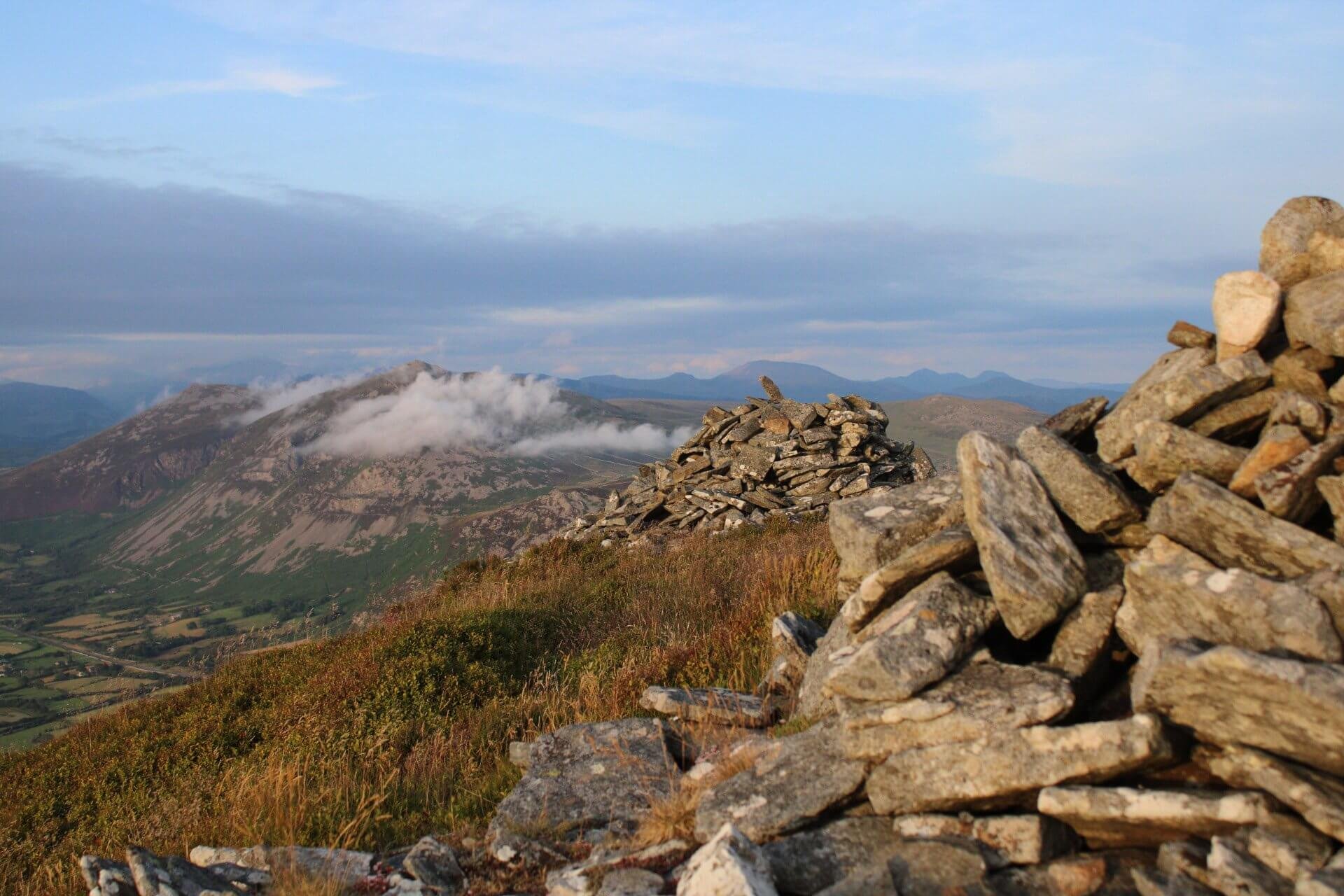
Mynydd Mawr (From Rhyd Ddu)
Distance: 4.6km (2.9 miles)
Ascent: 503m (1,650 feet)
Mynydd Mawr (698 meters, 2,290 feet) —often called “Elephant Mountain” thanks to its distinctive shape—may look imposing from a distance, but the hike is surprisingly approachable. Aside from a few steep walking sections, it’s a rewarding and manageable climb with panoramic views over Nantlle, Yr Wyddfa (Snowdon), Yr Eifl, and the Irish Sea. Especially enjoyable on a warm summer afternoon.
The route starts just above the village of Rhyd Ddu, following a forest track that winds above Llyn Cwellyn for about a mile and a half. After this, the trail climbs through the trees to meet the main path ascending the mountain’s western flank. From here, the views open up—especially across the dramatic Nantlle Ridge. While the trail does get steep in places, the tough sections don’t last long. You'll soon reach a broad plateau with impressive views down Craig y Bera and across the Nantlle Valley. One final push takes you to the summit cairn, where you’re rewarded with sweeping views over the Irish Sea and Anglesey.

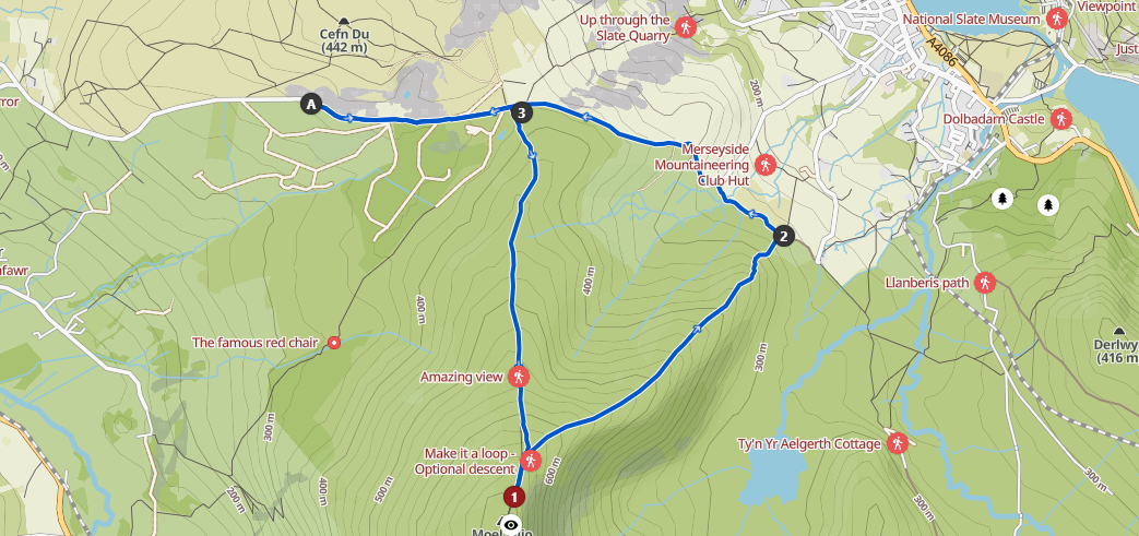
Moel Eilio (From Cefn Du)
Distance: 8.3km (5.2 miles)
Ascent: 457m (1,500 feet)
Moel Eilio (726 meters, 2,382 feet), meaning "Eilio's Hill" in English, derives its name from the Welsh word "Moel," which translates to "hill" or "mountain." The "Eilio" part is believed to be a personal name, though there’s no clear historical figure tied to this smooth, rounded summit.
The hike begins at the old quarry workings of Cefn Du, where the trail gradually ascends Moel Eilio’s western side. While the path is fairly steep, the terrain is easy to navigate, requiring a steady climb of 457 meters to the summit. Once you reach the top, you’ll be rewarded with stunning panoramic views, including vistas of Llanberis, the Elidirs, and Wyddfa (Snowdon), along with sights of Anglesey and Llandudno in the distance. You can either backtrack to the beginning for a shorter walk or loop down the south flank bringing you conveniently back to your starting point at Cefn Du.
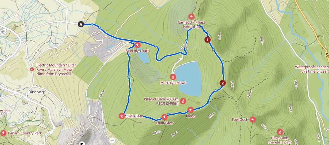
Elidir Horseshoe (Marchlyn Loop)
Distance: 9.7km (6 miles)
Ascent: 616m (2,025 feet)
The Elidir Range marks the northernmost part of the Glyderau Mountains and is named after the legendary 6th-century warrior king, Eliffer Gosgorddfawr (also known as Elidir of the Great Army). Nestled behind Elidir Fawr, you wont miss the Marchlyn Mawr Reservoir which serves as the primary water source for the Dinorwig Power Station.
The hike begins at the base of Marchlyn Mawr above Deniolen / Dinorwig, where you'll follow a private (open access) winding tarmac road that gradually ascends. Along the way, you'll reach the path leading up to Carnedd Y Filiast (821m, 2,694ft), offering panoramic views over the Atlantic Slabs, Anglesey, and the Bay of Llandudno. From there, the trail takes you to the summit of Mynydd Perfedd (813m, 2,667ft), providing breathtaking vistas of the Ogwen Valley. The next stop is Elidir Fawr (924m, 3,031ft) rewarding hikers with impressive views of the Wyddfa (Snowdon) range. As you descend, you'll pass Elidir Fach (795m, 2,608ft), with a final look over the Slate Mines before completing the loop back to the starting point.
Moel Siabod (Daear Ddu Ridge)
Distance: 9.5km (5.9 miles)
Ascent: 686m (2,250 feet)
Moel Siabod (872m, 2,861 ft) stands proudly above the small village of Dolwyddelan and is the highest peak in the Moelwynion mountain range. On a clear day, it's said that you can spot 13 of the 14 highest peaks in Wales from its summit without even turning your head.
The hike starts at Pont Cyfyng, just a short distance from Capel Curig, which could also serve as an alternative parking and starting point. The path gently ascends towards the old quarry workings and picturesque quarry lakes. As you continue upward, you'll reach a large, quiet Cwm (valley) before passing the charming, small lake of Llyn y Foel. From here, the path steepens toward the scramble of Dear Ddu Ridge. It’s graded as a grade 1 scramble on some sections but most hikers should find it manageable enough, though you’ll likely need to use your hands in certain parts. Once at the top of Moel Siabod, the views over the Snowdonia range are absolutely stunning. The loop continues around, and you’ll descend the northeastern ridge, eventually making your way back down to Pont Cyfyng.

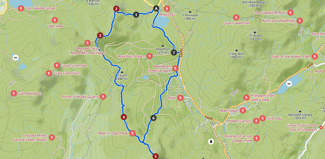
Nantlle Ridge to Moel Hebog (Coed Beddgelert Loop)
Distance: 17.8km (11 miles)
Ascent: 1,200m (3,937 feet)
If you're after a full-day leg-stretcher with unforgettable views, this hike starts along the Nantlle Ridge before crossing Cwm y Ddwy Elor and heading into the Hebog range, covering Moel Lefn, Moel Yr Ogof, and Moel Hebog. Expect incredible panoramas across the Nantlle Valley, stretching out to Anglesey, and stunning sights across the Rhyd Ddu Valley toward Yr Wyddfa.
The route begins in Rhyd Ddu, following the same start as the classic Nantlle Ridge walk. After a steep climb up Y Garn, there's a chance to catch your breath before the hands-on scramble across Mynydd Drws y Coed. Once you’ve topped out on Trum y Ddysgl, the trail drops into the broad, scenic expanse of Cwm y Ddwy Elor with plenty of quarry workings to explore. From here, you can either turn back through Beddgelert Forest or continue on into the Hebog range proper. The next summit is Moel Lefn, offering wonderful views over Porthmadog and Anglesey. From there, you head to Moel Yr Ogof, famous for being one of Owain Glyndŵr’s caves, Ogof Owain Glyndŵr, which is tucked away on the steep southern flank of the mountain, the authenticity of the location can’t be proven though he was well known as having various advantageous guerilla positions in the Eryri hills looking out across the Irish Sea and the Menai straits.
At the col (bwlch) before Moel Hebog, you have another chance to descend early via the forest. But if you’ve still got the energy in the legs, it’s highly recommended to push on to the summit of Moel Hebog (783m, 2,568ft), where the views across Eryri are well worth the effort. From there, the route backtracks to the bwlch and descends into the majestic Beddgelert Forest, passing the peaceful lakes of Llyn Llywelyn and Llyn y Gadair before looping back to the starting point.